


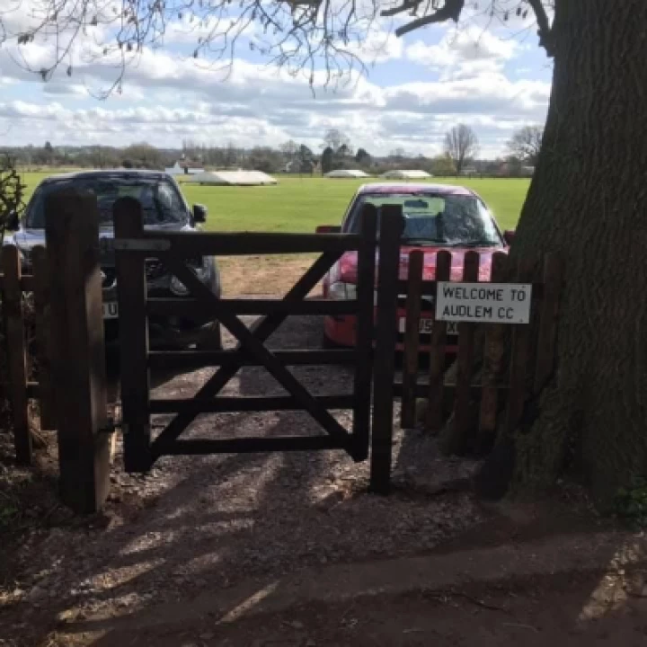
Last week, AudlemOnline reported that the Cheshire East Public Rights of Way committee would discuss making the path up the steps from the Shroppie Fly's car park and then across the football field an official public footpath.
We also added that it was unlikely that the so-called disabled flatter path from the end of the Shroppir car park to the more northern end of the playing field would be approved.
This is, indeed, what happened. This is the report from Mondays' meeting – it's lengthy, so much so that we are not publishing all the supporting documents, but it is fair to say the committee gave the issue a very good going over:
Wildlife and Countryside Act 1981 – Part III, Section 53. Application No. CN/7/22: Application for the Addition of a Public Footpath Between Public Footpath Audlem No. 28 and Cheshire Street, Audlem
Meeting of Public Rights of Way Committee, Monday, 15th June, 2015 2.00 pm (Item 7.)
To consider the application for the addition of a Public Footpath between Public Footpath Audlem No. 28 and Cheshire Street, Audlem
Minutes:
The Committee received a report which detailed an investigation into an application to for the addition of a public footpath between Public Footpath No.28 and Cheshire Street, Audlem.
Under Section 53 of the Wildlife and Countryside Act 1981, the Borough Council had a duty, as surveying authority, to keep the Definitive Map and Statement under continuous review. Section 53 (3)(c) allowed the Authority to act on the discovery of evidence that suggests that the Definitive Map and Statement needed to be amended.
The Authority must investigate and determine that evidence and decide on the outcome whether to make a Definitive Map Modification Order. The event relevant to this application was Section (3)(c)(i), which required modification of the map by the addition of a right of way: -
- The discovery by the authority of evidence which(when considered with all other relevant evidence available to them) shows-
- That a right of way which is not shown in the map and statement subsists or is reasonably alleged to subsist over land in the area to which the map relates.
Where the evidence in support of the application is user evidence, Section 31(1) of the Highways Act 1980 applied -
"Where a way.... has been actually enjoyed by the public as of right and without interruption for a full period of twenty years, the way is deemed to have been dedicated as a highway unless there is sufficient evidence that there was no intention during that period to dedicate."
Section 31(2) states that "the 20 years is calculated retrospectively from the date when the right of the public to use the way is brought into question."
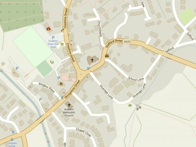
The application had been submitted in April 2005 by Audlem Parish Council to modify the Definitive Map and Statement for the parish of Audlem by adding a currently unrecorded route as a Public Footpath. The route applied for ran from Public Footpath No.28 Audlem, on the towpath to the south east of the Shroppie Fly Public House and ran in a generally north easterly direction to join Cheshire Street, Audlem – points A-B-D-E on Plan No.WCA/008.
An additional loop had also been claimed, from point D running north westerly through the pub car park then northerly up a grassy slope to point C, then turning south easterly along the top of a bank through a wooded area back to point B. The application was based on user evidence; a total of 10 user evidence forms were submitted with the application.
John White, North and Mid Cheshire Ramblers, spoke in support of the application and confirmed that he had used the claimed route as the Ramblers had used the car park as a start point for their walks.
A detailed investigation of all the evidence submitted with the application had been undertaken, together with additional research. In addition to the user evidence, an investigation of the available historical documentation had been undertaken to establish whether the claimed route had an earlier origin.
From the historical documentation investigation, no evidence of the route claimed was found on the 18th and 19th Century County Maps, the Audlem Tithe Map and Apportionment 1846, the Ordnance Survey Maps 6" to 1 mile, 1st, 2nd and 3rd Editions and the Ordnance Survey Maps 25" to 1 mile, 1st. 2nd and 3rd Editions. The claimed route was not recorded in the Audlem Parish Survey completed in 1952 for the Definitive Map and Statement.
A total of ten user evidence forms were submitted, all claiming the use of the route on foot. Officer had interviewed seven of the witnesses. Use of the route ranged from 1969 until the application was submitted in April 2005. The frequency of use varied between daily, weekly and occasionally. The route was used as a link to access the Shroppie Fly public house, canal and the village shops on Cheshire Street. It was also used recreationally and for leisure purposes, such as a dog walk.
The relevant twenty year period to be considered for this application was 1985 to 2005. From the information on the user evidence forms, eight witnesses stated use of the claimed route on foot for the full 20 year period and two stated use for part of this period.
Seven witnesses were interviewed by officer and had signed statements. Five of the seven interviewed claimed to have used the route on foot for the full twenty year period and two stated use for part of the period.
All the witnesses were consistent in describing the route they used – from Cheshire Street, across the playing fields (at the tennis court side, behind the goal posts) and down the steps at The Shroppie Fly to the towpath. None of the witnesses interviewed had been stopped or challenged when walking this path. All of them stated that they did not have permission to use the route, they had just assumed it was a public path.
Only two witnesses interviewed claimed to have used the loop B-C-D and this was only occasional use. Consequently this evidence was not sufficient to show rights had been acquired.
Cheshire East Council's Park Management had been consulted and had concerns that if an Order was made and confirmed, as events were held on the playing field occasionally, these could potentially obstruct the footpath.
They were also concerned that a public footpath would cause operational difficulties between walkers and those playing formal sports on the playing field. The Definitive Map Modification application process looked at unrecorded existing public rights and not dedicated new public rights, and health and safety issues could not be taken into account.
Cheshire East Council's insurance team had also been consulted and stated that they had no issue from an insurance point of view but suggested that if the application was successful suitable warning signs for drivers using the car park to watch out for pedestrians and vice versa would be appropriate.
The Canal and River Trust, Punch Partnership Ltd and one of the landowners had not objected to the application. One landowner had commented on the accuracy of the Plan as it showed the claimed path passing through a fenced off area. It was confirmed that the Plan would be amended to show the correct line of the claimed path if approved.
The report concluded that there was sufficient user evidence to support the existence of a footpath along the route A-B-D-E but insufficient use for the route B-C-D.
The Committee considered the historical and user evidence outlined in the report and the Definitive Map Officer's conclusions and considered that there was sufficient user evidence to support the existence of footpath rights along the route A-B-D-E but there was insufficient evidence to support the existence of footpath rights along route B-C-D.
The Committee considered that, on the balance of probabilities, the requirements of Section 53(3)(c)(i) had been met in the first instance and that the Definitive Map and Statement should be modified to add the claimed route as a Public Footpath.
The Committee unanimously resolved that:
- 1 The application to modify the Definitive Map and Statement to record a footpath between points B-C-D, as shown on Plan No.WCA/008, be refused on the grounds that there is insufficient evidence to show the existence of Public Footpath rights.
- 2 An Order be made under Section 53(3)(c)(i) of the Wildlife and Countryside Act 1981 to modify the Definitive Map and Statement by adding as a Public Footpath, the route shown between points A-B-D-E on Plan No.WCA/008.
- 3 Public Notice of the making of the Order be given and, in the event of there being no objections within the specified period or any objections received being withdrawn, the Order be confirmed in exercise of the powers conferred on the Council by the said Act.
- 4 In the event of objections to the Order being received, Cheshire East Borough Council be responsible for the conduct of any hearing or public inquiry.
Supporting documents:
Committee Report Plan, item 7. pdf icon PDF 402 KB
Committee Report – Audlem, item 7. pdf icon PDF 85 KB
Appendix 1 DMMO Research Checklist – Audlem, item 7. pdf icon PDF 28 KB
Audlem User evidence chart – UEF – Appendix 2, item 7. pdf icon PDF 14 KB
Audlem User evidence chart – interviews – Appendix 3, item 7. pdf icon PDF 16 KB
This article is from our news archive. As a result pictures or videos originally associated with it may have been removed and some of the content may no longer be accurate or relevant.
Get In Touch
AudlemOnline is powered by our active community.
Please send us your news and views using the button below:
Email: editor@audlem.org